Jim’s preface: Affordable housing in Charlottesville + Albemarle (and America) is at, or nearing, crisis stage. I love this post because I learned a lot from it. I hope you do, too.
- The housing crisis isn’t just about affordability—it’s about economic mobility, too
- Community land trusts take aim at rising rents
- Affordable Housing At Critical Stage
- The Global Housing Crisis
What we are doing locally to address affordable housing is not working. I’m grateful for a community of very interested and informed people in Charlottesville furthering this conversation, and seeking to find solutions.
by Matthew Gillikin
Housing, particularly the lack of affordable housing, has been a major topic in Charlottesville lately. As part of educating myself on how we got to this point, I asked folks on Twitter to weigh in on the most important milestones in Charlottesville area housing since 1950. A bunch of great responses followed. I turned their responses and some research I had done into a tweet storm, which I present to you now in a more readable form.
One thing has become clear to me: the high cost of Charlottesville and Albemarle County housing and the significant racial disparities within our housing system are not due to unexplainable flukes – they are in fact that way by design, often intentional, though sometimes accidental.
Below is a chronological “greatest hits” of Charlottesville area housing policy and projects. I am sure it is not complete and am happy for others to provide updates and corrections. My hope is a better understanding of this history will help us create real solutions to our housing problems.
- 1950: Population: Albemarle County – 26,666, Charlottesville – 25,969, UVA enrollment – 4,222
- 1954 – Charlottesville Redevelopment and Housing Authority (CRHA) created after referendum vote narrowly passes. (more)
- 1956 – With support of CRHA, Harland Bartholomew Associations (HBA) contracted to develop city’s first comprehensive plan.
Take a minute and read that piece about Harland Bartholomew – he’s a big deal in the history of U.S. city planning who, among other things, made destroying African-American neighborhoods seem like a great idea to the white power structure.
- 1957 HBA sends letter to Charlottesville planning commission suggesting prioritization of single family homes, banning row housing, and banning professional offices from residential areas
- 1959 School Desegregation (after city schools were shut down in 1958 during “Massive Resistance”)
- 1959 Charlottesville accepts HBA’s housing report to guide housing and slum clearing. (here, here)
March 2, 1959: Council notes that the Charlottesville Planning Commission will be using Harland Bartholomew's Housing Report as policy guide pic.twitter.com/LZKrtdf8Da
— Lyle Solla-Yates (@LyleSollaYates) October 9, 2017
1957: Harland Bartholomew Assoc. publish housing plan map, charting desirable white neighborhoods, those in trouble, and those to be removed pic.twitter.com/J4ELCOaPay
— Lyle Solla-Yates (@LyleSollaYates) November 2, 2017
1960: Population: County – 30,969, City – 29,427 , UVA – 5,047
1960 Voters pass referendum for redevelopment of Vinegar Hill
1961 Referendum on whether Cox’s Row should become public housing site passes
1963 On site of Cox’s Row, which was knocked down, Westhaven constructed to house displaced residents of Vinegar Hill. Construction completed in 1964. It has 126 units.
1964 Vinegar Hill razed. Limited subsequent development on the site for next 20 years.
1967 Garret Street neighborhood clearing approved by city council. Covers about 57 acres
1969 First record of affordability problems with City Yard expansion on Page
1970: Population: County – 37,780, City – 38,880, UVA – 10,852
1970 Byrd Organization (the Democratic party machine that controlled much of Virginia for decades in the middle of the 20th century) loses control of Cville, leading to HBA being kicked out, new city manager.
1970 Federal government gives CRHA $3.8 million for Garret Street redevelopment.
1971 Albemarle County adopts its first comprehensive plan.
1975 Page Street connection to downtown removed
1976 Crescent Halls, a 105 unit apartment building, is built under authority of CRHA.
1976 Downtown Mall opens, designed by Lawrence Halprin.
1978 – Garret Square (aka Friendship Court) built. Privately owned, but managed by CRHA. In 2002, Piedmont Housing Alliance partnered with National Housing Trust to buy and redevelop Friendship Court. 150 units.
1980: Population: County – 55,783, City – 39,916, UVA – 16,452
1980 – CRHA creates policy designed to create 50/50 race mix in public housing, eventually revised to 65% black. Resulted in black applicants having longer wait times. Policy suspended after HUD reviewed.
1980-81 Riverside (16 units), Sixth St. (25), Madison Ave (18), Michie Dr (23), and South First St (58) public housing sites built, all managed to this day by CRHA
1982 – Revenue Sharing agreement between Albemarle County and Charlottesville City
1985 City opens a hotel on Downtown Mall, which loses money, is then sold and becomes the Omni.
1990: Population: County – 68,040, City – 40,341, UVA – 18,137
1991 City downzoning – Significant portion of city residential land is downzoned to R-1, aka single family homes. This is a huge shift in land use regulations for the city.
2000: Population: County – 79,236, City – 40,099, UVA – 18,550
2003 Corridor zoning – increased by-right density, particularly near UVA campus. Significant uptick in development for student housing on JPA, Wertland, and 14th Street areas
2010: Population: County – 98,970, City – 43,475, UVA – 21,049
2010 Martha Jefferson Hospital relocation
2013 City begins to consider Form Based Code, which to this day only Kathy Galvin understands
2016 Virginia General Assembly changes proffer statute, narrowing conditions for which impact fees can be applied, significant impacting Albemarle County.
2017: Population: County – 107,697, City – 49,132, UVA – 22,805
2018 CHRA manages 376 public housing units and around 300 section 8 vouchers. Around 2000 people are housed through these programs, or about 1 in 20 of Cville’s non-student residents.
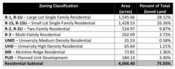
Finally, here are a couple of charts on the current housing situation in Charlottesville City that I am kind of obsessed with and wanted to share. The first is on the makeup of the city’s housing stock. You will see that 50% of housing units in the city are single-family homes. The second is how much of zoned city land is taken up by each residential zoning classification. You will see that about 55% of city land is zoned for R-1 housing, which is the single-family classification. It makes sense that when the majority of housing and land are dedicated to the most expensive type of housing (single-family), affordability problems will follow.